Rating: strenous, Challenging, Passes to climb 5 passes
Maximum elevation
Kanji-la 5271 m
Pingdon-la 5029 m
Barma-la 4695 m
Murgum-La 4370 m
Sengi-La 4971 m By Car
Average daily walking time
6-7 hours
Best Time Early June – Ending August
Rout: Less crowded and Remoteness
DAY 01 Leh – Kanji village (3800 m), 6 hours drive, 165 Kms from Leh
Today we will drive to Kanji along towards west Ladakh, along the bank of Indus river, we visit Lamayuru monastery and corss Fotola pass, enter the narrow gorge of Kanji valley, by pass Henaskut village.
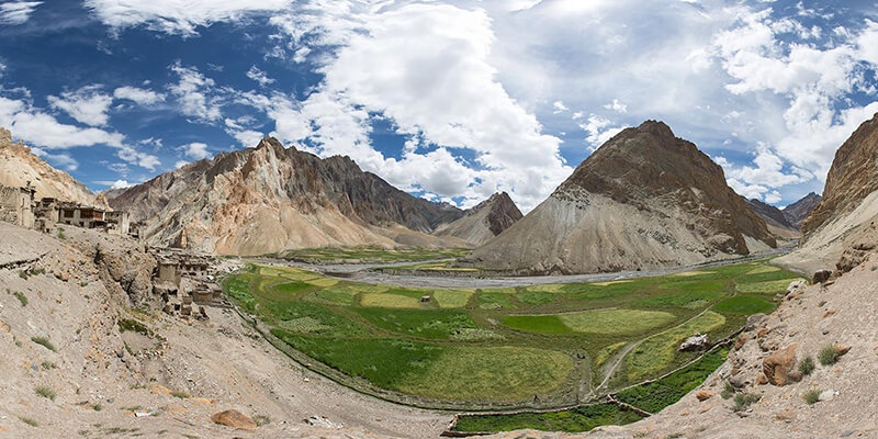
reach Kanji and setup our camp at Kanji village. This is one of the ancient village of Ladakh, beautiful barley field and tradition houses. People here are mostly depend on farm and cattle, yak, goats and sheep. Overnight at Camp
Campsite altitude 3800 mtrs
Day 02 Kanji (3800 m) – to base of Kanji-La (4350 m), 6 hours
We start our trek early morning towards Kanji la pass base, the trek will be easy and gradual ascend, walk along the beautiful stream and pasture land of Kanji. Set up camp at the base of Kanji la.
Campsite altitude 4350 mtrs
Day 03 Base Kanji la – Kanji-la (5271 m)
Junction of Kanji-La & Pingdong-La (4370 m) 7 hours, Today it will be a challenging day we climb Kanjila – pass, after we summit the pass, we can have the breath-taking view of the Zanskar mountain range, the trans Himalayan ranges, among them you can see the Nun Kun view. Later we descend towards Doksa, and junction Pigdong la, from where one can also trek to Rangdum monastery. The trail will be rocky and shallow. Set up camp at Doksa
Camp site altitude 4370 mtrs
Day 04 Junction to base Pingdong la (4579), 4-5 hours.
Today we will cross the Pigdong la pass and the trail is easy and you can see the beautiful mountain range of Dipling, the region is also the home of Himalayan brown bear, later we descend trek towards other side of pass and setup camp.
Altitude at the camp site 3800 mtrs
Day 05 Base Pingdon la – Pingdon la (5029 m) – Dibling (4700 m), 7 hours
Easy climb to the pass. You will be able to see that your path leading to the pass is an easy snow-slog. Crampons and ice axes are unnecessary and it is unlikely you will need gaiters.
Pingdon-la or Pudzong-la has view on the Zanskar range: superb – snowy peaks in every direction. Leaving the pass, snow slopes and then rocks lead to a gulch down which the zigzag path brings you out past fantastic rock walls and towers on either side to the wide valley. About 900 meters of descend and you walk amongst an area of clumpy small trees and bushes with fabulous views. Now you walk easily down the left-hand side of the valley past some deserted houses and some unworked fields before coming to the river entering from the left. Here you have the choice of either wading across or perhaps riding across on a horse, if one can be made available from the pack animals.
Campsite altitude 4500 mtrs
Day 06
Dibling – Lingshed sumdho (3680 m) – Base Barma la (3890 m), 8 hours Leaving the village, we follow a relatively newly-built footpath and after a while some parts of the path are exposed.
Long day on a narrow and rocky path. The path traverses slopes into the gorge. Fantastic rock scenery. Gigantic slabs on the right further down ahead of you. Horses have to walk in the river. You can walk in water or climb up to avoid fords. Eventually you cross the main river again to take you back to the left bank. The scenery is jaw-dropping – beetling cliffs with choughs and pigeons soaring the heights. Even eagles might come to see who these strangers are. You may encounter local people from the village of Dibling whose nearest place to shop is the village of Lingshed. At Lingshed Sundho we enter a gorge coming in from the left, leave the valley of Oma Chu (milk river) and walk up to the base of Barma-la (Barmi-la). The path enter a narrow section of the gorge and look back now for fabulous views of snow-capped peaks framed by the wall of the gorge. Meet some caves and, at the end of the gorge, we camp at 3.680 m. or may be higher at 3900 m.
Camp site altitude 3680 mtrs
DAY 07 Base – Barma la (4.694 m) – Lingshed Gompa (3900 m), 6-7 hours
Easy climb.Long descent to the Gompa campsite.
It is just over three hours to the pass and an easy gradual path until the last 300 metres which is a little steeper. There are one or two places where you would not want to slip on the narrow path! Looking back, the views are inspiring – ranges of snow peaks. As you get higher, the trail turns to the left and then again to the right. The pass itself is broad, with a chorten and prayer flags. It is such a thrill to get to the pass and look down into the valley containing the village and monastery of Lingshed, and the peaks marching off into the far distance. It is a long and hot descent, but the views go on improving of Lingshed and its wonderful monastery.
Campsite altitude 3850 mtrs
DAY 08
Drive back to Leh by crossing Singge la, pass 4850 Mtrs, photoksar village, and cross Ser, Ser la pass, drive along the Hanupata la pass and along the Wanla village, and reach Leh by late evening.
The road is recently connected to Lingshed and it will be bumpy and jumpy, but definitely you will enjoy the beautiful landscape of Singee la pass and Photoksar. It will be a long day drive and you will reach Leh around 6 PM.
Copyright © 2026, Active Adventure | Developed By AlgoPage IT Solutions Pvt. Ltd.